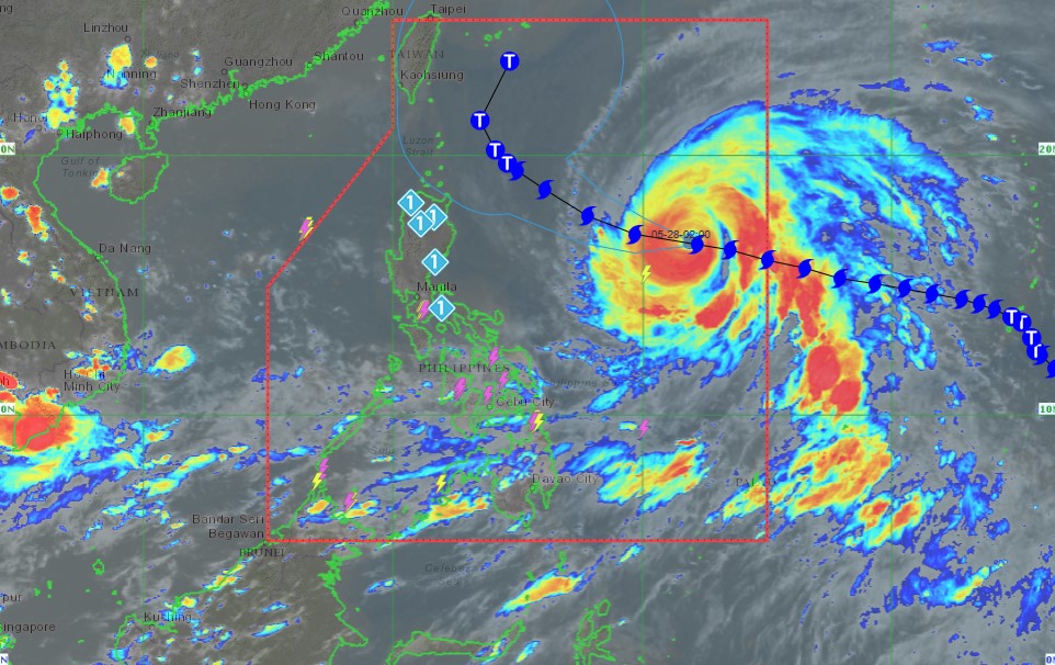
Super Typhoon Betty (international name: Mawar) has slightly weakened as it moves westward north of the Philippines, according to the local weather agency in its 5PM May 27, 2023 bulletin.
Super Typhoon Betty is forecast to track westward in the next 12 hours before turning west northwestward. On Monday, the tropical cyclone will turn northwestward and decelerate as it moves over the waters east of Extreme Northern Luzon.
Betty may eventually become almost stationary between late Tuesday and early Wednesday when it will be closest to Batanes (i.e., within 250-300 km).
Betty is forecast to remain as a super typhoon over the weekend. Although it will likely maintain its strength for the next 36-48 hours, short-term intensification is not ruled out especially in the next 12 to 24 hours.
However, this tropical cyclone may begin weakening considerably on Monday or Tuesday during its slowdown period over the waters east of Batanes due to potential unfavorable conditions (e.g., effect of upwelling of cooler ocean water and dry air intrusion).
The center of the eye of Super Typhoon Betty was estimated based on all available data at 1,035 km East of Central Luzon (16.7 °N, 131.8 °E ).
Tropical Cyclone Wind Signal no. 1:
Batanes, Cagayan including Babuyan Islands, Isabela, Apayao, Ilocos Norte, the northern and central portions of Abra (Tineg, Lacub, Lagayan, San Juan, Lagangilang, Licuan-Baay, Malibcong, Danglas, La Paz, Dolores, Tayum, Bucay, Sallapadan, Daguioman, Bucloc, Boliney), Kalinga, the eastern and central portions of Mountain Province (Sadanga, Barlig, Natonin, Paracelis, Bontoc), the eastern and central portions of Ifugao (Mayoyao, Aguinaldo, Alfonso Lista, Banaue, Hingyon, Lagawe, Lamut, Kiangan, Asipulo), the northern and central portions of Aurora (Dilasag, Casiguran, Dinalungan, Dipaculao), Quirino and the northeastern portion of Nueva Vizcaya (Kasibu, Quezon, Solano, Bagabag, Diadi, Villaverde, Bayombong, Ambaguio).
BusinessNewsAsia
